
The maps below show the changes that took place in Youngsville in New Zealand over a 25-year period from 1980 to 2005. Summarize the changes in an essay of at least 150 words and make comparisons where necessary.
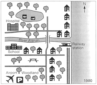
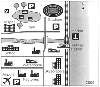
The maps illustrates how Youngsville in New Zealand developed through 25 years from 1980 to 2005.
To the North of Alanah river, in 1980, there were many trees around the lake and on both sides of the street. In 2005, many trees were cut down to make way for building a Parking lot to the North of the lake and a park to its South. More sports activities were also added to the lake area. Besides, in the South-West corner of this part of the map, a hospital still remained throughout the period; however, in the East of this part of Youngsville, the houses in 1980 were all replaced by a stadium and also a parking lot to its South. Along the sea coast, in 2005, people extended the railway and built a marina near the rail bridge.
To the South of the river Alanah, between the river bank and the main street, after 25 years, the school was retained but small houses and trees were cleared for the construction of factories and warehouses. In the South West corner of Youngsville, the airport and the parking facility were still the same but the trees around them were cut down and factories were built. Additionally, along the coast, in 2005 skyscrapers emerged where there had been only small houses and trees.
Overall, after 25 years, Youngsville developed from a rural to a developed industrial area. (234 words)