
MAP DESCRIPTION IN IELTS WRITING TASK 1
Two types of maps:
- Maps of changes of a place over time
- Maps of locations for building something
Examples of map description
Map 1
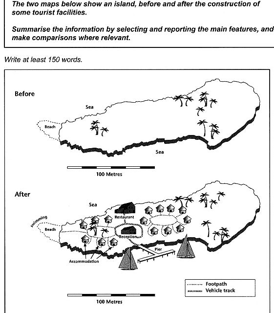
The maps demonstrate the transformation of an island under the impacts of the introduction of tourism.
It is clear that before the construction of tourist facilities, the island which was scattered with coconut trees was not inhabited. Now, guest houses, which are connected to each other by footpaths have sprung up in the central and Western part of the island. At the center of the lodging area, there is a reception, to the north of which a restaurant has been built.
In the south of the island, a pier has emerged, which allows boats to dock. From there, visitors are transported to the reception by vehicles on a designated track. In the west of the island, the beach has now been turned into a swimming area, where guests can conveniently access using the footpath.
Overall, a major part of the island underwent a transformation from a seemingly deserted island to a densely constructed tourist resort while the East coast still remained free from human interventions.
Map 2
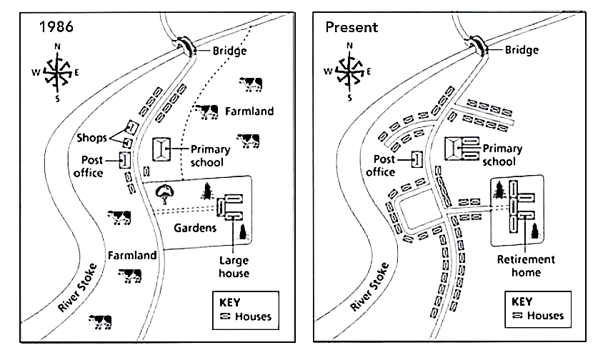
The maps show the changes of Denham town from 1986 to present.
A model answer adapted from www.IELTSfocus.com
The two maps illustrate the main changes which have taken place in the town of Denham since 1986 till now.
Overall, the town has most notably shown a move away from agriculture and farming and an increase in housing development, which indicates a higher population.
One change that stands out is that there has been a significant redevelopment over the whole period of what was once farmland. Housing now dominates the area to the East of the river Stoke. In 1986 there were shops, two large areas dedicated to farming activities, and just a handful of residential properties. Now there are no shops nor farmland left although the post office is still there. The bridge over the river Stoke still stands as it did in 1986.
Another noticeable change is that there have been more roads built to connect newly developed residential areas to the thoroughfare. Additionally, the gardens, that were a feature in 1986, have been removed and the large houses were expanded and converted into a retirement home. The primary school still stands and has been extended, but the fence toward the river that was running north of the gardens in 1986 is no longer there.
Map 3
An model answer adapted from www.IELTSbuddy.com
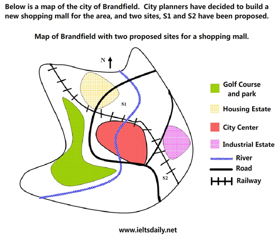
The map illustrates plans for two possible sites to the North and South of the city of Brandfield for the construction of a shopping mall.
The first possible site for the shopping mall, S1, is just north of the city centre, and north of the railway line which runs from the South-East of the city to the North-West. If built there, it will be next to a large housing estate, thus providing easy access for those living on the estate and in the city centre. It will also be next to the river, which runs through the town. On the other hand, the site to the South-East of the city, S2, is next to the railway line and fairly close to the city centre, but it is near an industrial estate rather than a residential area.
There is a main road that runs through the city and is close to both sites, thus providing good road access to both locations. However, a large golf course and park in the west of the town prevents this area from being available as a promising site for the facility.
Overall, to achieve better commercial value and more conveniently serve shoppers, the shopping mall should be constructed in the first site of S1.